Map of French-speaking Africa: the Sahel, Central Africa and the islands
Map of French-speaking Africa: what it shows
The map of French-speaking Africa shows twenty-six countries in two groups: twenty-one states where French is an official or working language and five countries where it plays an important role without official status. Its outline covers a broad continental band, from the Atlantic coast to the Congo Basin, extended by islands in the Indian Ocean and by Djibouti.
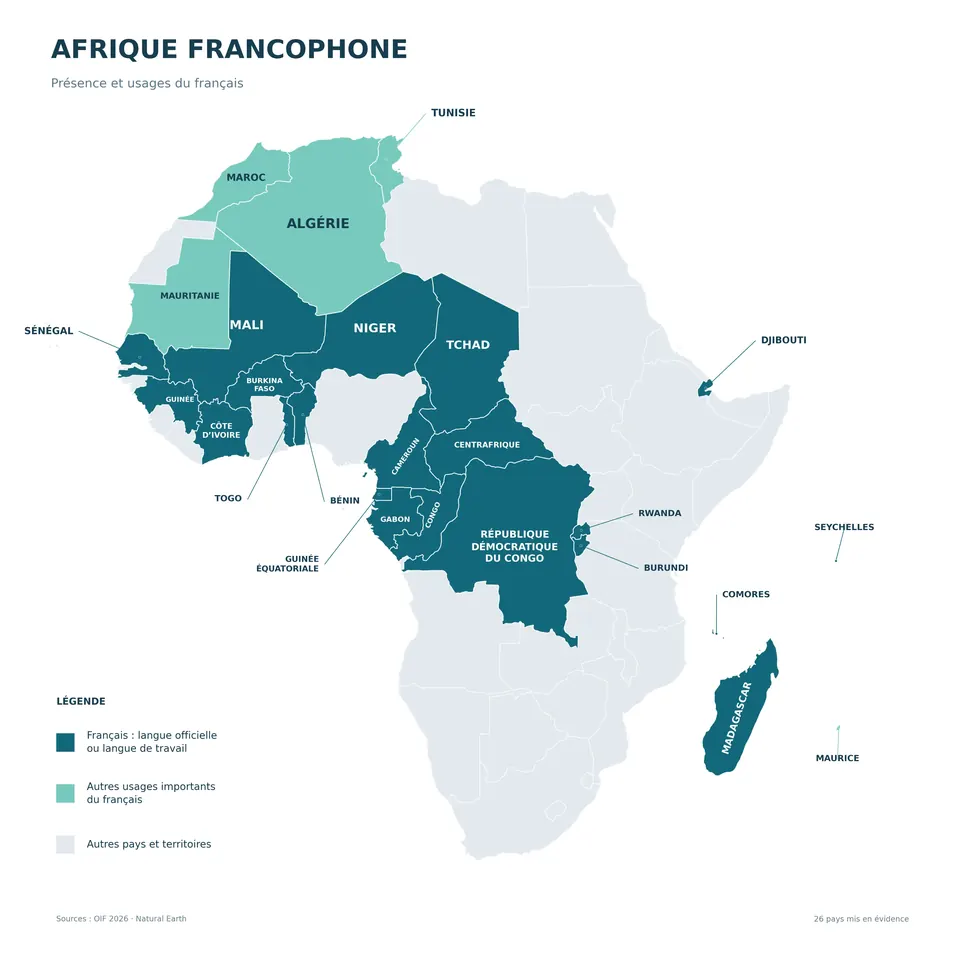
The twenty-one states where French is official or a working language
In West Africa, Senegal opens the band on the Atlantic. To the east come Mali, Burkina Faso and Niger, three landlocked countries in the heart of the Sahel. In the south, Benin, Togo, Ivory Coast (Côte d'Ivoire) and Guinea border the Gulf of Guinea or the Atlantic and form the maritime front of the region.
In Central Africa, landlocked Chad joins Cameroon, whose coast looks onto the Gulf of Guinea, followed by the Central African Republic, Gabon, the Republic of the Congo and Equatorial Guinea. The Democratic Republic of the Congo, a vast country crossed by the Congo River, has only a narrow opening to the ocean. In the east, Burundi and Rwanda, small in area, run along the Great Lakes.
In the Indian Ocean, Madagascar, the fourth-largest island in the world, the Comoros and Seychelles appear as isolated island groups. Djibouti, on the Gulf of Aden, holds a strategic position at the entrance to the Red Sea.
The five countries where French has other uses
In the north, Algeria, Morocco and Tunisia border the Mediterranean; Mauritania opens onto the Atlantic and the Sahara. These four countries have Arabic as their official language, and French remains present in higher education, business and the press. Mauritius, an island in the Indian Ocean, completes this group: English is the language of administration there, but French dominates in the media and in everyday use.
Territorial continuity of the map, from Senegal to the Democratic Republic of the Congo
On the continent, the French-speaking states form an almost continuous group from Senegal to the Democratic Republic of the Congo. Senegal, Mali, Burkina Faso, Niger and Chad follow one another from west to east along the Sahel, then Cameroon, the Central African Republic and the Democratic Republic of the Congo extend this axis towards the south and the centre of the continent. Senegal also borders Guinea.
This continuity has interruptions. The Gambia forms an English-speaking enclave around the river within Senegal. Ghana separates Ivory Coast from Togo, Nigeria lies between Benin and Cameroon, while Portuguese-speaking Guinea-Bissau sits between Senegal and Guinea on the coast. English-speaking Sierra Leone and Liberia separate Guinea from Ivory Coast along the coastline.
French is therefore the common language of a group of more than twenty neighbouring countries, which English, Portuguese and Spanish cut across in places. The Indian Ocean islands and Djibouti remain apart from this territorial block, while sharing the same use of the language.